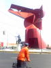
 Ciudad Nezahualcóyotl’s main symbol: The coyote. Very small, in front of it, you can see a state of Aztec Emperor Nezahualcóyotl.
Gunnar Wolf - Nice grey life - page 61
Showing posts 601 – 610
Ciudad Nezahualcóyotl’s main symbol: The coyote. Very small, in front of it, you can see a state of Aztec Emperor Nezahualcóyotl.
 The Northern edge of Cd. Nezahualcoyotl used to be Mexico City’s garbage dump, limited by one of the main open-air sweage systems. Its size is unbelievable – Huge is too small a word for it. After many years of being the dirtiest place in the city, it was shut down. Its land is poisoned unsuitable for basically anything. So, it was buldozered, leveled and covered in sand — and became an Ecological, recreational zone. The saddest, dirtiest ecological zone I’ve ever seen. A very surrealist setting. At least, recreational it is. Over the dead soil, 76 football fields were drawn....
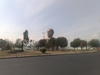 Very near Metro Guelatao (Línea A), and about a hundred meters South of Av. Ignacio Zaragoza, the limit between Estado de México (North) and Distrito Federal (South), and thus between Cd. Nezahualcóyotl (North) and Iztapalapa (South), is this colossal «Cabeza de Juárez» (Juárez’s head). Benito Juárez was president of Mexico in the 1860s-1870s; this monument is… as ugly as it can get. There is a little museum underneath, although we didn’t venture into it.
April 15 2012, my friend Alberto and I took on a difficult mission: Cross the –allegedly– biggest city in the world and conquer Ciudad Nezahualcóyotl, one of its populous and famous districts. Alberto had been to Cd. Neza a couple of times, as he is one of the providers for a physical rehabilitation center built in it, but I had never set foot in it. My friend Al and me started cycling in col. Escandón, in Mexico’s Center-West, followed roughly along Metrobús’ line 2 until its terminal, and at Cabeza de Juárez entered Cd. Neza. We went along the main...
 See the previous photo for some data on what Cabeza de Juárez is.
<h3>En el principio era el tiro parabólico</h3> <p>El desarrollo de juegos está relacionado con el desarrollo del cómputo prácticamente desde sus inicios. A pesar de que durante décadas las computadoras estaban al alcance únicamente de algunas grandes (y muy serias) instituciones militares y académicas, ya desde la década de 1940 hubo acercamientos lúdicos a diversos temas con fines de investigación: En 1947, Thomas T. Goldsmith Jr. y Estle Ray Mann diseñaron un primitivo sistema (controlado por una computadora de únicamente ocho bulbos) que mostraba en una pantalla tipo televisión la trayectoria descrita por misiles, cuyos parámetros dependían de la posición...
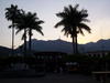
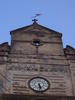 The oldest building in San Luis Potosí, built in 1550-1557 (the clock is a 1927 addition)
On this Semana Santa (holy/major week), Regina and I took a little vacation: We went ~400Km North, to the magical Xilitla, in the Eastern part of San Luis Potosí state. To get there, we went by the Sierra Gorda de Querétaro route: A beautiful but quite hard to drive road, crossing desert, forest and jungle through a very steep mountain ridge. What does hard to drive mean? It means that for ~200Km we had a speed average of 40-50Km/h. The road is in very good conditions, and traffic was quite light. And although our plans were to come back via...
subscribe via RSS